Geography · Regions · West Africa
Map of The Gambia
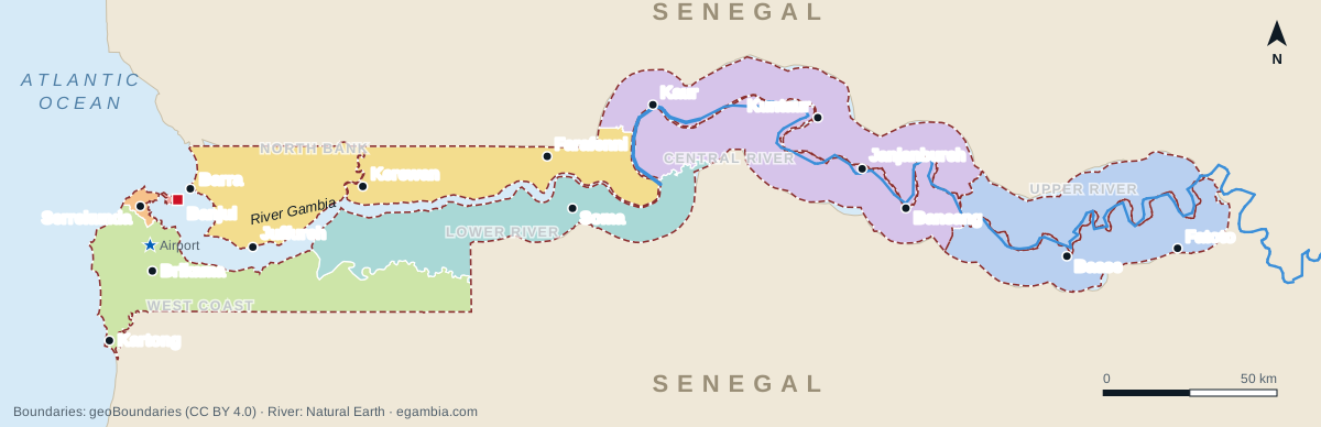
The Gambia is a small country in West Africa that follows the River Gambia inland from the Atlantic Ocean. It is surrounded by Senegal on every side except its short western coast. The map below shows its regions, main towns and the river. Further down you can see where The Gambia sits on the map of Africa, and there is an interactive map you can zoom into.
The Gambia map with regions and towns
- City of Banjul
- Kanifing
- West Coast
- North Bank
- Lower River
- Central River
- Upper River
The Gambia at a glance
These figures are rounded. They are here to give a sense of scale, not official measurements.
- Capital
- Banjul
- Largest urban area
- Serrekunda
- Area
- ≈ 11,300 km²
- Length (west–east)
- ≈ 330 km
- Width
- ≈ 10–50 km
- Atlantic coastline
- ≈ 80 km
- Neighbour
- Senegal only
- Coordinates (Banjul)
- 13.45° N, 16.58° W
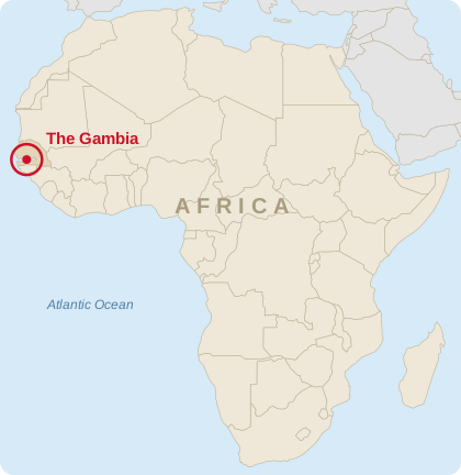
Where is The Gambia on the map of Africa?
The Gambia is on the Atlantic coast of West Africa, at about 13° north of the equator and 16° west of Greenwich. On a map of Africa, look at the far western bulge of the continent. Find Senegal and its capital, Dakar, on the tip. The Gambia is the thin strip cutting into Senegal a little to the south-east.
It is the smallest country on the African mainland. Senegal surrounds it to the north, east and south, and the Atlantic Ocean lies to the west. The southern part of Senegal, the Casamance, sits between The Gambia and Guinea-Bissau. On a world map, The Gambia is at roughly the same latitude as Honduras, Chennai or Bangkok, and it uses GMT all year round.
Regions of The Gambia
The Gambia is divided into five regions and two municipalities. For local government these form eight areas, because the Central River Region is split into Kuntaur and Janjanbureh. The two municipalities, Banjul and Kanifing, hold a large share of the population on only a sliver of the map. The table lists them from west to east.
| Region / municipality | Main town | Bank of the river | What to know |
|---|---|---|---|
| City of Banjul | Banjul | South (island at the river mouth) | The capital, on St Mary's Island. Government, port and ferry to Barra. Banjul guide |
| Kanifing Municipality | Serrekunda | South | The most densely populated area: Serrekunda, Bakau, Fajara, Kotu and Kololi. Serrekunda guide |
| West Coast Region | Brikama | South | Fast-growing towns, the airport, coastal villages such as Tanji, Gunjur and Kartong. Brikama guide |
| North Bank Region | Kerewan | North | Barra, Juffureh and Kunta Kinteh Island, Niumi National Park, Farafenni. Roots heritage |
| Lower River Region | Mansa Konko | South | Soma crossroads, Tendaba and Kiang West National Park. |
| Central River Region | Janjanbureh / Kuntaur | Both | Janjanbureh island, the Wassu stone circles, River Gambia National Park. Janjanbureh guide |
| Upper River Region | Basse Santa Su | Both (mainly south) | The easternmost region: a trading hub near the Senegal border, with farming along the river. |
Interactive map
Zoom and drag to explore. The markers show main towns, national parks and reserves, heritage sites and the two main river crossings. Select a marker for a short note. Marker positions are approximate.
Why is The Gambia shaped like a river?
The shape comes from colonial history. In the 1800s Britain controlled trade along the River Gambia, while France held the surrounding land that became Senegal. An Anglo-French agreement in 1889 fixed the border as a strip running roughly 10 km either side of the river, as far inland as the navigable trading stations. That is why the country is long and narrow and follows the bends of the water.
A popular story says the border was set by how far a British gunboat's cannon could fire from the river. It is folklore, but it captures the idea well: the country is the river corridor. The history guide covers this in more detail.
How to read the map
Start at the coast. Banjul sits on an island at the river mouth. Serrekunda, Bakau, Kotu, Kololi and the Senegambia strip lie a few kilometres west and south of it. Most hotels, restaurants and beaches are within a short drive of each other, and Banjul International Airport at Yundum is about half an hour inland.
Follow the river east. The estuary is several kilometres wide near Banjul and narrows steadily as you go inland past mangroves, wetlands and savannah. Towns sit on either bank: Farafenni and Soma face each other near the middle of the country, then Janjanbureh on its river island, and Basse near the eastern end. The River Gambia guide describes what you see along the way.
Remember the two banks. Roads run along the north and south banks, and there are only a few ways across. On the coast, the Banjul–Barra ferry links the capital to the north bank. Inland, the Senegambia Bridge between Farafenni and Soma opened in 2019 and carries the main road link between northern and southern Senegal. Smaller crossings exist upriver. The driving guide and getting around guide cover practical details.
Physical geography
The Gambia is low and flat. Most of the country is less than 50 metres above sea level. Near the coast you find sandy beaches, dunes and coastal forest. The lower river is lined with mangroves and tidal creeks (called bolongs), and salt water pushes a long way inland in the dry season. Further east, the land becomes savannah woodland and farmland, and the river runs between freshwater swamps used for rice.
The climate has two seasons. The dry season runs roughly from November to May and is the main travel season. The rainy or green season runs roughly from June to October. Inland areas get hotter than the breezy coast. See best time to visit for a month-by-month view.
Using the map to plan a trip
Because the country is compact, a coastal base works for most short trips. Beaches, birding sites such as Abuko and Tanji, Banjul and the markets of Serrekunda are all within an hour or so. The classic excursions are Juffureh and Kunta Kinteh Island across the river, and an overnight trip upriver to Tendaba, Janjanbureh or the River Gambia National Park. See day trips and sample itineraries for routes that fit the map.
For business and logistics, the map explains why activity concentrates on the coast. The port of Banjul, the airport and most of the population all sit in the west, while the inland corridor is mainly agricultural. The trade and logistics guide goes into more detail.
Map questions, answered
Where is The Gambia on the map?
The Gambia is in West Africa on the Atlantic coast, at roughly 13° N and 16° W. It is a narrow strip of land along the River Gambia, surrounded by Senegal on the north, east and south, with the Atlantic Ocean to the west.
What countries border The Gambia?
Only one: Senegal, which surrounds The Gambia on three sides. The Atlantic Ocean forms its western edge. Guinea-Bissau and Guinea are nearby but do not share a border with it.
What are the regions of The Gambia?
The Gambia has five regions (West Coast, North Bank, Lower River, Central River and Upper River) and two municipalities (the City of Banjul and Kanifing). For local government these are split into eight areas: Banjul, Kanifing, Brikama, Kerewan, Mansakonko, Kuntaur, Janjanbureh and Basse.
Why does The Gambia follow the river?
Its borders were drawn by Britain and France in 1889. Britain held the river trade and France the surrounding land, so the boundary was set as a strip roughly 10 km either side of the River Gambia. The idea that it was fixed by cannon range is folklore.
How big is The Gambia?
About 11,300 square kilometres. It stretches roughly 330 km from the coast to its eastern tip, but is only about 10 to 50 km wide, making it the smallest country on the African mainland.
What is the capital of The Gambia?
Banjul, on St Mary's Island at the mouth of the River Gambia. The largest urban area is Serrekunda, a few kilometres inland in Kanifing Municipality.
Is The Gambia just a river?
No. The river runs through the middle of the country, but on each bank there is a strip of land with towns, farmland, forest and wetlands. Most people live on the land near the coast around Banjul, Serrekunda and Brikama.
Can I download or print this map of The Gambia?
Yes. The regions map on this page is available as a PNG and an SVG file that you can download, print or reuse with a credit to egambia.com.
Related reading
- The River Gambia: facts, width and places along it
- History of The Gambia and why it follows the river
- People and culture of The Gambia
- Getting around inside The Gambia
- Where to stay
- National parks and reserves
- Banjul city guide
- Travel overview
- Regions of The Gambia
- Geography of The Gambia
- Largest cities and towns
- Facts about The Gambia