Places · Regions · The Gambia
Regions of The Gambia: map and guide
The Gambia is divided into five administrative regions — West Coast, North Bank, Lower River, Central River and Upper River — plus two urban municipalities, the City of Banjul and Kanifing Municipality. For local government these make eight local government areas (LGAs). The regions run west to east along the River Gambia: the crowded Atlantic coast is in the far west, and the quieter farming regions stretch upriver towards the Senegal border in the east.
Map of The Gambia showing the regions
The map below shows the regions, the river and the main towns. For a zoomable version with more places marked, open our interactive map of The Gambia.
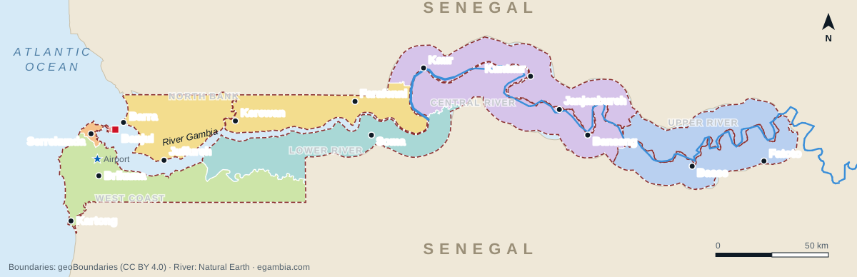
Two things make the regional map easy to read once you know them. First, the whole country is a narrow strip either side of the River Gambia, surrounded by Senegal except for its short Atlantic coast. Second, the river itself is the main dividing line: the North Bank Region lies entirely north of the river, while the West Coast and Lower River regions lie to its south. Further east, the Central River and Upper River regions straddle both banks.
The regions at a glance
| Region / municipality | Administrative centre | Local government area(s) | Where it is |
|---|---|---|---|
| City of Banjul | Banjul | Banjul | Island at the mouth of the river; the capital |
| Kanifing Municipality | Kanifing | Kanifing | Urban area just west of Banjul, including Serrekunda |
| West Coast Region | Brikama | Brikama | South of the river, from the Atlantic coast inland |
| North Bank Region | Kerewan | Kerewan | North of the river, from the coast at Barra eastwards |
| Lower River Region | Mansa Konko | Mansakonko | South bank, east of the West Coast Region |
| Central River Region | Janjanbureh | Kuntaur and Janjanbureh | Both banks in the centre of the country |
| Upper River Region | Basse | Basse | Both banks at the far eastern end |
The regions were formerly called divisions (Western Division, North Bank Division, and so on), and you will still see the old names in older books and maps. The West Coast Region was the Western Division, and the Central River Region was known as MacCarthy Island Division. Below the regions, the country is split into roughly 40 districts, many of which carry historic kingdom names such as Kombo, Niumi, Badibu, Kiang and Fulladu.
City of Banjul
Banjul, the capital, sits on St Mary's Island where the river meets the Atlantic. It is the smallest administrative area by far, with only around 30,000 residents according to the 2013 census, because the island has little room to grow. It holds the seat of government, the port, the Albert Market, Arch 22 and the ferry terminal for Barra. See the Banjul city guide.
Kanifing Municipality
Kanifing Municipality (KMC) is the dense urban belt west of Banjul and one of the most crowded places in West Africa. It includes Serrekunda and its many neighbourhoods, Bakau and Fajara, and the resort strip at Kotu and Kololi. For most visitors this is where hotels, restaurants and nightlife are; for residents it is the commercial heart of the country.
West Coast Region (Brikama)
If you are asking where the West Coast Region is, it is the whole south-western corner of the country: the Atlantic coast from Brufut south to Kartong, and the Kombo and Foni districts inland along the south bank. Its centre is Brikama, one of the country's largest towns. It is the most populous region and one of the fastest-growing, as the Greater Banjul urban area spreads south into towns such as Lamin, Sukuta, Brufut and Nema Kunku. Key places include Tanji, Sanyang, Gunjur, Kartong, Abuko Nature Reserve and Makasutu. The international airport at Yundum is also here.
North Bank Region (Kerewan)
The North Bank Region runs along the northern side of the river from Barra, opposite Banjul, eastwards to beyond Farafenni. Kerewan is the administrative centre, but Farafenni is the bigger town and a busy trading hub on the Trans-Gambia road to southern Senegal. Visitors come for Juffureh and Kunta Kinteh Island, the UNESCO-listed site linked to the story of Roots, and for Niumi National Park near the coast. Districts include Niumi, Jokadu and Badibu.
Lower River Region (Mansa Konko)
The Lower River Region lies on the south bank east of the Foni area. Its administrative centre is Mansa Konko, while nearby Soma is the larger town and the southern hub of the Trans-Gambia crossing, now served by the Senegambia Bridge. The region is thinly populated and rural, with mangrove-lined creeks and Kiang West National Park, one of the best places in the country for wildlife. Districts include Kiang and Jarra.
Central River Region (Janjanbureh)
The Central River Region straddles the river in the middle of the country and is the only region split into two local government areas: Janjanbureh (mainly south bank) and Kuntaur (north bank). Janjanbureh, the historic river town on MacCarthy Island, is the regional centre. The region holds the River Gambia National Park with its chimpanzee rehabilitation islands, the Wassu stone circles near Kuntaur, and some of the country's main rice-growing floodplains. Bansang is another important town.
Upper River Region (Basse)
The Upper River Region is the easternmost region, bordering Senegal on three sides. Basse Santa Su, usually just called Basse, is its busy market town and a trading centre for eastern Gambia and neighbouring parts of Senegal and Guinea. The area is drier and hotter than the coast, with districts such as Fulladu East, Kantora, Wuli and Sandu. Fatoto, further east, is one of the last Gambian towns on the river.
Border regions
Every region except Banjul touches Senegal, which surrounds The Gambia on the north, east and south. The busiest border areas are around Barra and Amdallai in the North Bank Region, Farafenni on the Trans-Gambia route, Seleti in the West Coast Region on the road south to Ziguinchor, and around Basse in the far east. Border rules and opening hours can change, so check with official sources before relying on a particular crossing.
Travelling between the regions
- The South Bank Highway runs from the coast through Brikama, Soma and Janjanbureh to Basse; the North Bank Highway links Barra, Kerewan, Farafenni and eastwards.
- River crossings include the Banjul–Barra ferry and the Senegambia Bridge between the Farafenni and Soma areas.
- Upriver trips are easiest with a driver or an organised tour; see the getting-around guide and driving guide.
- For an idea of how to fit the regions into a trip, see our sample itineraries and River Gambia guide.
Frequently asked questions
How many regions does The Gambia have?
The Gambia has five regions — West Coast, North Bank, Lower River, Central River and Upper River — plus two municipalities, the City of Banjul and Kanifing. Together they form eight local government areas, because the Central River Region is split into Janjanbureh and Kuntaur.
What are the eight local government areas of The Gambia?
Banjul, Kanifing, Brikama (West Coast Region), Kerewan (North Bank Region), Mansakonko (Lower River Region), Janjanbureh and Kuntaur (Central River Region), and Basse (Upper River Region).
Where is the West Coast Region in The Gambia?
The West Coast Region covers the south-western part of the country, south of the river, from the Atlantic coast between Brufut and Kartong inland through the Kombo and Foni districts. Its main town is Brikama.
Which is the easternmost region of The Gambia?
The Upper River Region, centred on Basse, is the furthest east. It borders Senegal on the north, east and south.
Which region is Serrekunda in?
Serrekunda is in Kanifing Municipality, the urban area just west of Banjul. It is not part of the West Coast Region, although the built-up area continues across the boundary into towns such as Sukuta and Lamin.
What were the regions of The Gambia called before?
They were called divisions, for example Western Division and North Bank Division. The Central River Region was previously known as MacCarthy Island Division.
What to read next
- Map of The Gambia — zoomable map of regions and towns.
- Largest cities and towns — where people live.
- Geography of The Gambia — river, coast and climate.
- Facts about The Gambia — the essentials at a glance.
- Basse — the Upper River Region.
- Janjanbureh — the Central River Region.